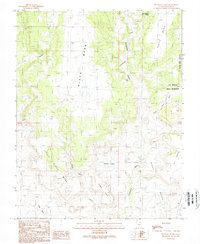
1989 Map of No-mans Island
USGS Topo · Published 1989About this map
Black Mesa and White Mesa dominate this San Juan County landscape, where deep drainages like Cottonwood Wash and Stevens Canyon carve through high desert plateaus. The eastern edge of the quadrangle is defined by the Ute Mountain Indian Reservation boundary, while the central terrain features the isolated No-Mans Island landform.
Find a feature on this map
20 named features on this map. Tap any name to fly to it.
Don’t see what you’re looking for? This feature index may not catch every label — zoom into the map to look around manually.
Map Details
Editions of this 1989 No-mans Island Map
This is the sole edition of this map. No revisions or reprints were ever made.
Other maps of this area

1886 · Abajo
USGS Topo · 1:250,000

1892 · Abajo
USGS Topo · 1:250,000

1893 · Abajo
USGS Topo · 1:250,000

1935 · Elk Ridge
USGS Topo · 1:96,000

1940 · Elk Ridge
USGS Topo · 1:125,000

1956 · Cortez
USGS Topo · 1:250,000

1957 · Elk Ridge 4 SE
USGS Topo · 1:24,000

1957 · Brushy Basin Wash
USGS Topo · 1:62,500

1957 · Blanding
USGS Topo · 1:62,500

1958 · Cortez
USGS Topo · 1:250,000