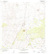
1956 Map of Nohonaohae
USGS Topo · Published 1977About this map
Waikoloa and the surrounding Kohala district lands are defined here by a series of prominent volcanic cones and the essential infrastructure required to support mid-century ranching and transit. The volcanic landforms of Nohonaohae, Puu Papapa, and Mahoelua dominate the landscape, standing as distinct landmarks amid an intricate network of Fence Lines and Pipelines. This infrastructure, alongside water-management features like the Old Aalii Pump Station and Pawila Pump Station, reveals the effort to sustain livestock and human settlement on this high-elevation terrain.
Find a feature on this map
28 named features on this map. Tap any name to fly to it.
Don’t see what you’re looking for? This feature index may not catch every label — zoom into the map to look around manually.
Map Details
Editions of this 1956 Nohonaohae Map
2 editions found
Other maps of this area

1913 · Kohala
USGS Topo · 1:62,500

1916 · Kohala
USGS Topo · 1:62,500

1916 · Waipio
USGS Topo · 1:62,500

1928 · Puako
USGS Topo · 1:62,500

1954 · Hawaii North
USGS Topo · 1:250,000

1956 · Puu Hinai
USGS Topo · 1:24,000

1956 · Kamuela
USGS Topo · 1:24,000

1956 · Keamuku
USGS Topo · 1:24,000

1956 · Nohonaohae
USGS Topo · 1:24,000

1956 · Makahalau
USGS Topo · 1:24,000