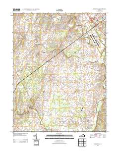
2013 Map of Nokesville
USGS Topo · Published 2013About this map
Nokesville and Bristow anchor this landscape south of Manassas, where suburban growth meets established agricultural and aviation centers. The Manassas Regional Airport occupies the northeastern corner, while the southern boundary includes a portion of the Quantico Marine Corps Base at Camp Upshur. Historically significant crossings and early industrial sites are still preserved in the nomenclature, including the Nokesville Truss Bridge over Kettle Run and Daniels Mill on Cedar Cr. Small communities like Kings Crossroads, Aden, and Brentsville are connected by a network of rural roads that pass by Thoroughbred Farms and Nova Turf Farm, illustrating the area's transition from traditional Virginia farmland to a modern residential and aviation hub. Numerous creeks such as Slate Run and South Run drain the terrain toward the southeastern woods.
Find a feature on this map
116 named features on this map. Tap any name to fly to it.
Don’t see what you’re looking for? This feature index may not catch every label — zoom into the map to look around manually.
Map Details
Editions of this 2013 Nokesville Map
This is the sole edition of this map. No revisions or reprints were ever made.
Other maps of this area

1890 · Mt. Vernon
USGS Topo · 1:125,000

1891 · Mt. Vernon
USGS Topo · 1:125,000

1894 · Warrenton
USGS Topo · 1:125,000

1894 · Mt. Vernon
USGS Topo · 1:125,000

1897 · Mt. Vernon
USGS Topo · 1:125,000

1915 · Fairfax
USGS Topo · 1:62,500

1927 · Quantico
USGS Topo · 1:62,500

1933 · Middleburg
USGS Topo · 1:62,500

1940 · Quantico
USGS Topo · 1:62,500

1943 · Quantico
USGS Topo · 1:62,500