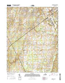
2016 Map of Nokesville
USGS Topo · Published 2016About this map
Linton Hall and the developing suburbs of Manassas anchor the northern landscape of this Prince William County survey, where modern infrastructure meets the rural Piedmont. The area is defined by a dense network of watercourses including Broad Run, Kettle Run, and Slate Run, which converge as they flow toward the Quantico Marine Corps Base in the southeast. This portion of the Culpeper Basin preserves several small traditional settlements and crossroads like Aden, Nokesville, and Kings Crossroads, many of which grew around early transportation routes and milling sites like Daniels Mill. Local history is deeply etched into the land through a series of family and community burying grounds, including White Hall Cem, Colvin Cem, and Rose Hill Cem. Significant engineering and aviation landmarks are also present, notably the Nokesville Truss Bridge and the sprawling Manassas Regional Airport/Harry P Davis Field.
Find a feature on this map
129 named features on this map. Tap any name to fly to it.
Don’t see what you’re looking for? This feature index may not catch every label — zoom into the map to look around manually.
Map Details
Editions of this 2016 Nokesville Map
This is the sole edition of this map. No revisions or reprints were ever made.
Other maps of this area

1890 · Mt. Vernon
USGS Topo · 1:125,000

1891 · Mt. Vernon
USGS Topo · 1:125,000

1894 · Warrenton
USGS Topo · 1:125,000

1894 · Mt. Vernon
USGS Topo · 1:125,000

1897 · Mt. Vernon
USGS Topo · 1:125,000

1915 · Fairfax
USGS Topo · 1:62,500

1927 · Quantico
USGS Topo · 1:62,500

1933 · Middleburg
USGS Topo · 1:62,500

1940 · Quantico
USGS Topo · 1:62,500

1943 · Quantico
USGS Topo · 1:62,500