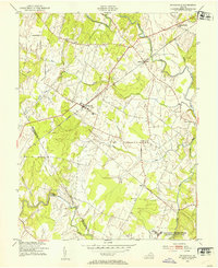
1953 Map of Nokesville
USGS Topo · Published 1954About this map
Nokesville serves as a central hub in the mid-1950s rural landscape of Northern Virginia, where the Southern railroad line cuts a straight path through the rolling hills of Prince William County. Small settlements and rural crossroads like Bristow, Brentsville, and Aden anchor the local community, which is largely defined by a dense network of watercourses including Broad Run, Kettle Run, and Cedar Run. This era shows the transition between purely agricultural land and the expansion of military infrastructure, evidenced by the southern border reaching into the US Naval Reservation Quantico Marine Base and Camp Upshur. Genealogists may find value in the specific placement of country churches such as Woodlawn Ch, Valley View Ch, and Ashbury Ch, which stood as vital social centers before the significant suburban development of later decades. The map also clearly delineates the boundary between Prince William Co and Fauquier Co in the western reaches.
Find a feature on this map
20 named features on this map. Tap any name to fly to it.
Don’t see what you’re looking for? This feature index may not catch every label — zoom into the map to look around manually.
Map Details
Editions of this 1953 Nokesville Map
This is the sole edition of this map. No revisions or reprints were ever made.
Other maps of this area

1890 · Mt. Vernon
USGS Topo · 1:125,000

1891 · Mt. Vernon
USGS Topo · 1:125,000

1894 · Warrenton
USGS Topo · 1:125,000

1894 · Mt. Vernon
USGS Topo · 1:125,000

1897 · Mt. Vernon
USGS Topo · 1:125,000

1915 · Fairfax
USGS Topo · 1:62,500

1927 · Quantico
USGS Topo · 1:62,500

1933 · Middleburg
USGS Topo · 1:62,500

1940 · Quantico
USGS Topo · 1:62,500

1943 · Quantico
USGS Topo · 1:62,500