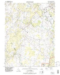
1994 Map of Nokesville
USGS Topo · Published 1997About this map
Nokesville and the surrounding Prince William County landscape appear here in a period of transition during the mid-1990s. The map illustrates the convergence of historic rural elements and growing infrastructure, notably where the southern edge of the City of Manassas meets the agricultural fields of the Piedmont. Evidence of the area's older agricultural and industrial roots is found at the Shale Pit and Claypit, while the aviation needs of the region are represented by Manassas Municipal Airport (Davis Field) and several smaller private landing strips. Numerous family and community burial grounds, such as Rose Hill Cem and Colvin Cem, are preserved across the terrain. Waterways like Broad Run and Kettle Run dictate the topography, passing through settlements like Bristow and Brentsville, the latter being a significant local historical site. The southern reaches are defined by the northern boundary of the Quantico Marine Corps Base near Camp Upshur.
Find a feature on this map
28 named features on this map. Tap any name to fly to it.
Don’t see what you’re looking for? This feature index may not catch every label — zoom into the map to look around manually.
Map Details
Editions of this 1994 Nokesville Map
This is the sole edition of this map. No revisions or reprints were ever made.
Other maps of this area

1890 · Mt. Vernon
USGS Topo · 1:125,000

1891 · Mt. Vernon
USGS Topo · 1:125,000

1894 · Warrenton
USGS Topo · 1:125,000

1894 · Mt. Vernon
USGS Topo · 1:125,000

1897 · Mt. Vernon
USGS Topo · 1:125,000

1915 · Fairfax
USGS Topo · 1:62,500

1927 · Quantico
USGS Topo · 1:62,500

1933 · Middleburg
USGS Topo · 1:62,500

1940 · Quantico
USGS Topo · 1:62,500

1943 · Quantico
USGS Topo · 1:62,500