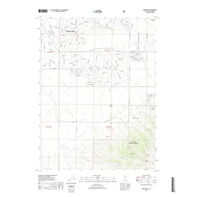
2018 Map of Noon Rock
USGS Topo · Published 2018About this map
Spring Creek anchors the northern portion of this Nevada survey, showing an intricate residential street network that transitions into the high-desert drainages of Pleasant Valley and South Fork Valley. This modern map illustrates the expansion of suburban-style developments, like those along Country Club Pkwy, set against the stark topography of the Ruby Mountains. To the south, the landscape becomes increasingly dramatic as it enters the Humboldt National Forest. Here, the terrain is defined by deep cuts such as Seitz Canyon and Hennen Canyon, leading up to the namesake Noon Rock. The map reveals a high-altitude water system critical for this arid environment, featuring numerous named sources like Cottonwood Spring, Big Spring, and the Dry Farm Reservoir. The proximity of modern residential life to the primitive mountain basins like Cottonwood Basin and The Island highlights the unique character of this Elko County region.
Find a feature on this map
130 named features on this map. Tap any name to fly to it.
Don’t see what you’re looking for? This feature index may not catch every label — zoom into the map to look around manually.
Map Details
Editions of this 2018 Noon Rock Map
This is the sole edition of this map. No revisions or reprints were ever made.
Other maps of this area
1935 · Halleck
USGS Topo · 1:125,000

1955 · Elko
USGS Topo · 1:250,000
1957 · Elko East
USGS Topo · 1:24,000

1958 · Elko
USGS Topo · 1:250,000

1962 · Elko
USGS Topo · 1:250,000
1962 · Boyd Reservoir
USGS Topo · 1:24,000
1962 · Elko East
USGS Topo · 1:24,000
1962 · Lee
USGS Topo · 1:62,500
1962 · Lamoille
USGS Topo · 1:62,500

1965 · Elko
USGS Topo · 1:250,000