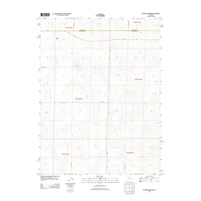
2013 Map of Noonen Reservoir
USGS Topo · Published 2013About this map
Muddy Cr and its tributaries define the drainage patterns of this eastern Colorado landscape, where the high plains meet the development edge of the Denver basin. The namesake Noonen Reservoir sits as a central water feature, supported by seasonal flows through Bouldin Gulch and First Cr. This 2013 survey illustrates the rigid grid of the Public Land Survey System, with section lines and township boundaries like t004s r059w clearly marked across the terrain. While Us-36 E provides the primary transit corridor across the northern reach, the map reveals a burgeoning network of rural-residential roads such as S Hayward Rd and S Bixler Rd, tracing the early 21st-century transition of traditional ranching tracts into smaller landholdings along the Adams and Arapahoe County line.
Find a feature on this map
18 named features on this map. Tap any name to fly to it.
Don’t see what you’re looking for? This feature index may not catch every label — zoom into the map to look around manually.
Map Details
Editions of this 2013 Noonen Reservoir Map
This is the sole edition of this map. No revisions or reprints were ever made.
Other maps of this area
1951 · Leader SE
USGS Topo · 1:24,000
1953 · Denver
USGS Topo · 1:250,000

1954 · Limon
USGS Topo · 1:250,000
1956 · Peoria
USGS Topo · 1:24,000
1957 · Denver
USGS Topo · 1:250,000

1957 · Limon
USGS Topo · 1:250,000

1958 · Limon
USGS Topo · 1:250,000
1958 · Denver
USGS Topo · 1:250,000
1960 · Denver
USGS Topo · 1:250,000
1968 · Deer Trail
USGS Topo · 1:24,000