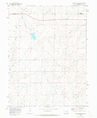
1969 Map of Noonen Reservoir
USGS Topo · Published 1973About this map
Noonen Reservoir and its associated Spillway form a central landmark in this high plains landscape of the late 1960s. The terrain is defined by the winding paths of Muddy Creek and First Creek, which carve through the open country. This area represents a rural corridor along the boundary of Adams and Arapahoe Counties, where the primary industrial footprints are several scattered Gravel Pits and a long Pipeline cutting diagonally across the topography. The map illustrates a transitional period of land use, where natural drainage features like Bolden Gulch remained largely undisturbed while early infrastructure began to mark the prairie.
Find a feature on this map
8 named features on this map. Tap any name to fly to it.
Don’t see what you’re looking for? This feature index may not catch every label — zoom into the map to look around manually.
Map Details
Editions of this 1969 Noonen Reservoir Map
This is the sole edition of this map. No revisions or reprints were ever made.
Other maps of this area

1951 · Leader SE
USGS Topo · 1:24,000

1953 · Denver
USGS Topo · 1:250,000

1954 · Limon
USGS Topo · 1:250,000

1956 · Peoria
USGS Topo · 1:24,000

1957 · Denver
USGS Topo · 1:250,000

1957 · Limon
USGS Topo · 1:250,000

1958 · Limon
USGS Topo · 1:250,000

1958 · Denver
USGS Topo · 1:250,000

1960 · Denver
USGS Topo · 1:250,000

1968 · Deer Trail
USGS Topo · 1:24,000