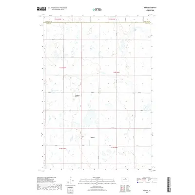
2017 Map of Norbeck
USGS Topo · Published 2017About this map
Millard and Norbeck anchor this survey of the agricultural interior of Faulk County. The landscape is defined by the Public Land Survey System, with a rigid grid of section lines and gravel roads such as 152nd St and 350th Ave crossing the prairie. In the southern portion of the quadrangle, the Millard Cem sits near the intersection of Co Rd 9 and Co Rd 4, serving as a vital landmark for genealogists and local historians tracing families in this rural township. Water is a scarce but defining element in this terrain, represented by the ephemeral Dry Lake and the small basin of Hanak Lake near the northern border with Edmunds County. The presence of Norbeck St within the small settlement of Norbeck reflects the quiet, established nature of these farming communities in the early 21st century.
Find a feature on this map
27 named features on this map. Tap any name to fly to it.
Don’t see what you’re looking for? This feature index may not catch every label — zoom into the map to look around manually.
Map Details
Editions of this 2017 Norbeck Map
This is the sole edition of this map. No revisions or reprints were ever made.
Other maps of this area
1951 · Clark Lake
USGS Topo · 1:24,000
1952 · Norbeck
USGS Topo · 1:24,000
1952 · Burkmere
USGS Topo · 1:24,000
1952 · Wecota
USGS Topo · 1:24,000
1952 · Faulkton West
USGS Topo · 1:24,000
1952 · Faulkton East
USGS Topo · 1:24,000
1954 · Aberdeen
USGS Topo · 1:250,000
1956 · Aberdeen
USGS Topo · 1:250,000
1974 · Ipswich SE
USGS Topo · 1:24,000
1978 · Loyalton
USGS Topo · 1:24,000