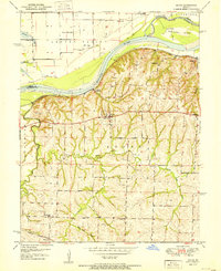
1957 Map of Norborne
USGS Topo · Published 1958About this map
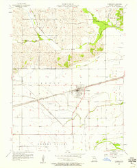
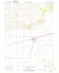
Norborne serves as the central hub of this Missouri landscape, where the dual corridors of the Atchison Topeka and Santa Fe and the Wabash railroads intersect. This 1957 survey by Thomas R. Beveridge reveals an agricultural region defined by distinct named terrains like Prairie and Egypt, while the southern expanse transitions into Cherry Valley and Sugartree. The mapping of several rural cemeteries, including Fairhaven Cem, Lutheran Cem, and Providence Cem, provides a detailed look at the scattered family and church burial sites that anchor the local history. Waterways like Wakenda Creek and Turkey Creek navigate the northern hills, while the southern bottomlands are shaped by the Drainage Ditch Spoil Bank and Moss Creek, illustrating the extensive mid-century efforts to manage the Missouri River floodplain for cultivation.
Find a feature on this map
27 named features on this map. Tap any name to fly to it.
Don’t see what you’re looking for? This feature index may not catch every label — zoom into the map to look around manually.
Map Details
Editions of this 1957 Norborne Map
2 editions found
Other maps of this area

1889 · Lexington
USGS Topo · 1:125,000
1949 · Lexington East
USGS Topo · 1:24,000

1950 · Lexington East
USGS Topo · 1:24,000
1950 · Dover
USGS Topo · 1:24,000
1951 · Dover
USGS Topo · 1:24,000

1951 · Waverly
USGS Topo · 1:24,000

1953 · Moberly
USGS Topo · 1:250,000

1954 · Moberly
USGS Topo · 1:250,000
1956 · Carrollton West
USGS Topo · 1:24,000

1957 · Moberly
USGS Topo · 1:250,000