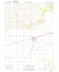
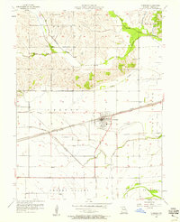
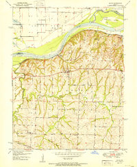
1957 Map of Norborne
USGS Topo · Published 1979About this map
Norborne sits at the nexus of the Missouri bottomlands and the rising prairie bluffs, serving as a critical rail hub for Carroll County. The landscape is defined by the sharp transition from the rugged northern hills of Prairie and Trotter to the low, flat expanse of Egypt and Cherry Valley. This map illustrates a highly managed hydrological system, where the winding courses of Wakenda Creek and Moss Creek contrast with the engineered straightness of the Drainage Ditch Spoil Bank.
Find a feature on this map
31 named features on this map. Tap any name to fly to it.
Don’t see what you’re looking for? This feature index may not catch every label — zoom into the map to look around manually.
Map Details
Editions of this 1957 Norborne Map
2 editions found
Other maps of this area

1889 · Lexington
USGS Topo · 1:125,000
1949 · Lexington East
USGS Topo · 1:24,000

1950 · Lexington East
USGS Topo · 1:24,000
1950 · Dover
USGS Topo · 1:24,000
1951 · Dover
USGS Topo · 1:24,000

1951 · Waverly
USGS Topo · 1:24,000

1953 · Moberly
USGS Topo · 1:250,000

1954 · Moberly
USGS Topo · 1:250,000
1956 · Carrollton West
USGS Topo · 1:24,000

1957 · Moberly
USGS Topo · 1:250,000