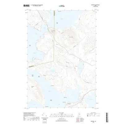
2018 Map of Norcross
USGS Topo · Published 2018About this map
The settlement of Norcross sits at a strategic narrows where the West Branch Penobscot River waters flow through a complex chain of glacial lakes. This 2018 survey documents a landscape dominated by interconnected water bodies including North Twin Lake, Elbow Lake, and Quakish Lake. To the north, the terrain rises sharply toward Black Cat Mtn and Hammatt Ridge, separating the lower basins from the expansive Millinocket Lake. A network of logging and access roads, such as Golden Rd and Baxter Park Rd, navigate the peninsulas and ridges that define the region's geography. The map reveals the intricate shoreline of Ambajejus Lake and Pemadumcook Lake, where features like Deep Cove and Indian Point Island mark the transition between open water and the wooded highlands of North Twin Ridge. This area serves as a primary gateway for those moving between the lower mill towns and the wilderness further north.
Find a feature on this map
45 named features on this map. Tap any name to fly to it.
Don’t see what you’re looking for? This feature index may not catch every label — zoom into the map to look around manually.
Map Details
Editions of this 2018 Norcross Map
This is the sole edition of this map. No revisions or reprints were ever made.
Other maps of this area

1927 · Katahdin
USGS Topo · 1:48,000

1930 · Katahdin
USGS Topo · 1:62,500

1949 · Katahdin
USGS Topo · 1:62,500

1951 · Norcross
USGS Topo · 1:62,500

1951 · Millinocket
USGS Topo · 1:62,500

1953 · Stacyville
USGS Topo · 1:62,500

1954 · Millinocket
USGS Topo · 1:250,000

1958 · Millinocket
USGS Topo · 1:250,000

1960 · Millinocket
USGS Topo · 1:250,000

1975 · Millinocket SW
USGS Topo · 1:24,000
Featured Places
- Millinocket, ME
- Ambejejus Lake, ME
- T3 Indian Purchase Township, ME
- T4 Indian Purchase Township, ME
- T1 R8 WELS, ME