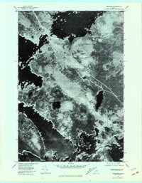
1978 Map of Norcross
USGS Topo · Published 1981About this map
Norcross occupies the southern edge of this orthophotoquad, serving as a gateway to the intricate waterway systems of northern Penobscot County. The 1978 aerial imagery reveals a landscape defined by expansive timberlands and a complex network of interconnected glacial lakes, including Millinocket Lake to the north and the sprawling North Twin Lake and South Twin Lake to the southwest. This specific survey captures the region's logging and recreational character before modern development, showing the clear timber management lines and road tracks that bypass Black Cat Mountain and Hammond Ridge. The visual data highlights the narrow channels and thoroughfares connecting bodies like Elbow Lake and Pemadumcook Lake, essential routes for both historic log drives and backcountry navigation.
Find a feature on this map
10 named features on this map. Tap any name to fly to it.
Don’t see what you’re looking for? This feature index may not catch every label — zoom into the map to look around manually.
Map Details
Editions of this 1978 Norcross Map
This is the sole edition of this map. No revisions or reprints were ever made.
Other maps of this area

1927 · Katahdin
USGS Topo · 1:48,000

1930 · Katahdin
USGS Topo · 1:62,500

1949 · Katahdin
USGS Topo · 1:62,500

1951 · Norcross
USGS Topo · 1:62,500

1951 · Millinocket
USGS Topo · 1:62,500

1953 · Stacyville
USGS Topo · 1:62,500

1954 · Millinocket
USGS Topo · 1:250,000

1958 · Millinocket
USGS Topo · 1:250,000

1960 · Millinocket
USGS Topo · 1:250,000

1975 · Millinocket SW
USGS Topo · 1:24,000
Featured Places
- Millinocket, ME
- T3 Indian Purchase Township, ME
- Ambejejus Lake, ME
- T1 R8 WELS, ME
- T4 Indian Purchase Township, ME