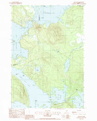
1988 Map of Norcross
USGS Topo · Published 1988About this map
Norcross sits at the southern edge of a vast island-flecked waterway in the late 1980s, where the waters of North Twin Lake and Elbow Lake converge. This Maine landscape is defined by its complex shoreline, characterized by prominent landmarks like Snake Pt, Haynes Pt, and Perrow Point. The interior is dominated by high ground, including Black Cat Mtn and Hammond Ridge, while the eastern portion of the sheet is traversed by a transmission line and a railroad serving Quakish Siding. To the north, the expanse of Millinocket Lake is dotted with features like Reed Island and Powers Point. The geography here reflects the intersection of managed timberlands and the deep-water lakes of the Penobscot region, partitioned by historic township lines such as T 3 Indian Purchase and T 1 R 8 W E L S.
Find a feature on this map
38 named features on this map. Tap any name to fly to it.
Don’t see what you’re looking for? This feature index may not catch every label — zoom into the map to look around manually.
Map Details
Editions of this 1988 Norcross Map
This is the sole edition of this map. No revisions or reprints were ever made.
Other maps of this area

1927 · Katahdin
USGS Topo · 1:48,000

1930 · Katahdin
USGS Topo · 1:62,500

1949 · Katahdin
USGS Topo · 1:62,500

1951 · Norcross
USGS Topo · 1:62,500

1951 · Millinocket
USGS Topo · 1:62,500

1953 · Stacyville
USGS Topo · 1:62,500

1954 · Millinocket
USGS Topo · 1:250,000

1958 · Millinocket
USGS Topo · 1:250,000

1960 · Millinocket
USGS Topo · 1:250,000

1975 · Millinocket SW
USGS Topo · 1:24,000
Featured Places
- Millinocket, ME
- T3 Indian Purchase Township, ME
- Ambejejus Lake, ME
- T1 R8 WELS, ME
- T4 Indian Purchase Township, ME