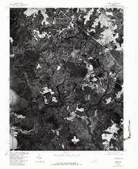
1978 Map of Norge
USGS Topo · Published 1983About this map
Norge and Lightfoot appear as growing communities in the late 1970s, as shown on this detailed orthophotoquad produced by the U.S. Geological Survey and the Soil Conservation Service. The landscape is characterized by the tidal wetlands and meandering path of the Chickahominy River along the western edge, where Yarmouth Creek feeds into the main waterway. This specific format of aerial imagery provides a direct look at the clearing of land for residential developments and agriculture during this period. Local sites of industrial or agricultural heritage, such as Warren Mill and Five Forks, anchor the road network, while Cranstons Pond and Jolly Pond dot the forested interior. The map captures James City County just as suburban patterns began to overlay the older rural infrastructure of Virginia's Tidewater region.
Find a feature on this map
8 named features on this map. Tap any name to fly to it.
Don’t see what you’re looking for? This feature index may not catch every label — zoom into the map to look around manually.
Map Details
Editions of this 1978 Norge Map
This is the sole edition of this map. No revisions or reprints were ever made.
Other maps of this area

1906 · Williamsburg
USGS Topo · 1:62,500

1907 · Yorktown
USGS Topo · 1:62,500

1917 · Toano
USGS Topo · 1:62,500

1918 · Toano
USGS Topo · 1:62,500

1919 · Surry
USGS Topo · 1:62,500

1943 · Yorktown
USGS Topo · 1:62,500

1943 · Richmond
USGS Topo · 1:250,000

1949 · Richmond
USGS Topo · 1:250,000

1950 · Cobham Bay
USGS Topo · 1:24,000
1951 · Williamsburg
USGS Topo · 1:24,000