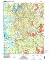
1994 Map of Norge
USGS Topo · Published 2000About this map
The Green Spring Ruins and the southern edge of the Colonial National Historical Park anchor this map of James City County, reflecting a landscape steeped in the colonial history of the Virginia Peninsula. The area is defined by the transition from the upland woods and ridges of Norge and Centerville to the extensive tidal marshlands and creeks of the Chickahominy River. To the north, the Little Creek Reservoir dominates the drainage patterns, while to the south, Powhatan Creek winds through a mosaic of residential developments and historic sites like Jamestown Farms. This survey captures the region as it navigated modernization during the late twentieth century, showing the balance between preserved historic sites and expanding educational and recreational hubs such as Lafayette High Sch, the Peninsula Scout Reservation, and the Golf Course.
Find a feature on this map
63 named features on this map. Tap any name to fly to it.
Don’t see what you’re looking for? This feature index may not catch every label — zoom into the map to look around manually.
Map Details
Editions of this 1994 Norge Map
This is the sole edition of this map. No revisions or reprints were ever made.
Other maps of this area

1906 · Williamsburg
USGS Topo · 1:62,500

1907 · Yorktown
USGS Topo · 1:62,500

1917 · Toano
USGS Topo · 1:62,500

1918 · Toano
USGS Topo · 1:62,500

1919 · Surry
USGS Topo · 1:62,500

1943 · Yorktown
USGS Topo · 1:62,500

1943 · Richmond
USGS Topo · 1:250,000

1949 · Richmond
USGS Topo · 1:250,000

1950 · Cobham Bay
USGS Topo · 1:24,000
1951 · Williamsburg
USGS Topo · 1:24,000