
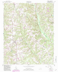
1950 Map of Norman
USGS Topo · Published 1953About this map
The town of Norman serves as the central hub of this mid-century survey, situated at the intersection of local routes and the Norfolk Southern railway line. The landscape is defined by the convergence of Richmond, Montgomery, and Moore Counties, where the headwaters of Naked Creek and Drowning Creek carve through the terrain. The area reflects a rural economy structured around small settlements and family-named landmarks, such as Emery and Rubyatt.
Find a feature on this map
34 named features on this map. Tap any name to fly to it.
Don’t see what you’re looking for? This feature index may not catch every label — zoom into the map to look around manually.
Map Details
Editions of this 1950 Norman Map
2 editions found
Other maps of this area

1942 · Troy
USGS Topo · 1:125,000

1949 · Millstone Lake
USGS Topo · 1:24,000

1949 · West End
USGS Topo · 1:24,000

1949 · Hoffman
USGS Topo · 1:24,000

1949 · Jackson Springs
USGS Topo · 1:62,500

1953 · Raleigh
USGS Topo · 1:250,000

1954 · Raleigh
USGS Topo · 1:250,000

1956 · Ellerbe
USGS Topo · 1:24,000

1956 · Harrisville
USGS Topo · 1:24,000

1957 · Troy
USGS Topo · 1:62,500