1976 Map of Norman
USGS Topo · Published 1978About this map
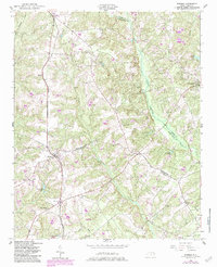
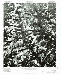
Norman serves as a primary hub of settlement in this 1976 orthophotoquad, which captures the rural landscape of Richmond County in the mid-1970s. This aerial-derived survey provides a clear view of the agricultural and forest patterns that defined the region before modern development patterns shifted. To the north, the small community of Emery sits near the map's boundary, while the eastern edge is marked by the vicinity of Jackson Springs. The terrain is physically defined by the drainage of Drowning Creek, where the darker texture of the orthophotograph indicates denser vegetation and lowland areas. Genealogists and local historians can trace the spatial relationship between these small communities and the outlying settlement at Plain View, seeing the exact footprint of farmsteads and rural roads as they existed during this era.
Find a feature on this map
5 named features on this map. Tap any name to fly to it.
Don’t see what you’re looking for? This feature index may not catch every label — zoom into the map to look around manually.
Map Details
Editions of this 1976 Norman Map
This is the sole edition of this map. No revisions or reprints were ever made.
Historical Maps of Norman Through Time
7 maps found