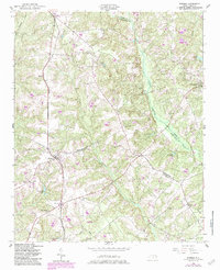
1950 Map of Norman
USGS Topo · Published 1983About this map
The town of Norman sits at the junction of the Norfolk Southern railroad and local thoroughfares, serving as a hub for the surrounding rural communities of Richmond, Montgomery, and Moore Counties. This mid-century landscape is defined by its numerous rural congregations and educational sites, including Belford Ch, Piney Grove Ch, and the Leakes Sch. The terrain is deeply carved by water systems like Naked Creek and Drowning Creek, which fed several private ponds such as Curries Pond and McCaskill Pond. To the south, the Sandhills Game Land occupies a significant portion of the territory near Rocky Ford Branch, suggesting a landscape shifting from small-scale agriculture and rail-side commerce to conservation and managed wilderness. The distribution of family-named landmarks like Derby and Rubyatt highlights the genealogy of the Piedmont region during this era.
Find a feature on this map
34 named features on this map. Tap any name to fly to it.
Don’t see what you’re looking for? This feature index may not catch every label — zoom into the map to look around manually.
Map Details
Editions of this 1950 Norman Map
2 editions found
Other maps of this area

1942 · Troy
USGS Topo · 1:125,000

1949 · Millstone Lake
USGS Topo · 1:24,000

1949 · West End
USGS Topo · 1:24,000

1949 · Hoffman
USGS Topo · 1:24,000

1949 · Jackson Springs
USGS Topo · 1:62,500

1950 · Norman
USGS Topo · 1:24,000

1953 · Raleigh
USGS Topo · 1:250,000

1954 · Raleigh
USGS Topo · 1:250,000

1956 · Ellerbe
USGS Topo · 1:24,000

1956 · Harrisville
USGS Topo · 1:24,000