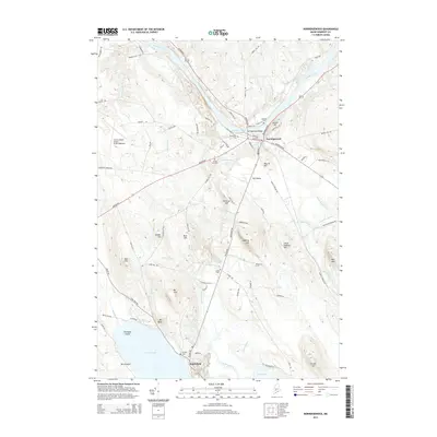
2014 Map of Norridgewock
USGS Topo · Published 2014About this map
The Kennebec River carves a deep arc through this Somerset County landscape, defined by the white water of Bombazee Rips and the historic river crossing at Norridgewock. The village layout follows the riverbank, where the Norridgewock Bridge connects the local road network at the junction of Main St and Madison Rd. To the south, the terrain rises into a series of family-named heights including McIntrye Hill, Dodling Hill, and Ross Hill, eventually sloping down toward the wetlands of The Serpentine. This waterway links North Pond and East Pond, where the village of Smithfield sits at the southern edge. Genealogists will find several burial grounds mapped across the township, such as Riverview Cem, Sunset View Cem, and the Old Oak Cem near the town center. The presence of the Central Maine Airport of Norridgewock signifies the area's role as a regional aviation hub amidst a landscape of brooks, streams, and traditional New England farm roads.
Find a feature on this map
93 named features on this map. Tap any name to fly to it.
Don’t see what you’re looking for? This feature index may not catch every label — zoom into the map to look around manually.
Map Details
Editions of this 2014 Norridgewock Map
This is the sole edition of this map. No revisions or reprints were ever made.
Other maps of this area

1892 · Waterville
USGS Topo · 1:62,500

1894 · Norridgewock
USGS Topo · 1:62,500

1898 · Norridgewock
USGS Topo · 1:62,500

1904 · Anson
USGS Topo · 1:62,500

1913 · Skowhegan
USGS Topo · 1:62,500

1943 · Norridgewock
USGS Topo · 1:62,500

1943 · Waterville
USGS Topo · 1:62,500

1948 · Bangor
USGS Topo · 1:250,000

1955 · Anson
USGS Topo · 1:62,500

1955 · Skowhegan
USGS Topo · 1:62,500