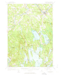
1956 Map of Norridgewock
USGS Topo · Published 1963About this map
The Kennebec River and Sandy River converge near the historic settlement of Norridgewock, anchoring a landscape defined by its intricate network of lakes and ponds. During the mid-twentieth century, this region supported a mix of agricultural hamlets like Starks and East Mercer alongside a growing seasonal recreation economy centered on the Belgrade Lakes chain. The Central Maine Railroad tracks parallel the river, serving the northern reaches of the quadrangle, while specialized sites like Pine Tree Camp and Camp Abena reflect the area's established role in Maine's summer camp tradition. Family-named landmarks such as Dodling Hill and Bigelow Hill rise above the many water bodies, including North Pond and East Pond. This mapping reveals the detailed infrastructure of the era, from the Norridgewock Airport to numerous country schoolhouses and cemeteries like Sunset View Cem, providing a clear record of local genealogy and community development.
Find a feature on this map
148 named features on this map. Tap any name to fly to it.
Don’t see what you’re looking for? This feature index may not catch every label — zoom into the map to look around manually.
Map Details
Editions of this 1956 Norridgewock Map
3 editions found
Other maps of this area

1892 · Waterville
USGS Topo · 1:62,500

1892 · Augusta
USGS Topo · 1:62,500

1893 · Vassalboro
USGS Topo · 1:62,500

1894 · Norridgewock
USGS Topo · 1:62,500

1898 · Norridgewock
USGS Topo · 1:62,500

1898 · Vassalboro
USGS Topo · 1:62,500

1904 · Anson
USGS Topo · 1:62,500

1910 · Livermore
USGS Topo · 1:62,500

1912 · Livermore
USGS Topo · 1:62,500

1913 · Skowhegan
USGS Topo · 1:62,500