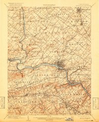
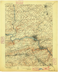
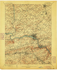
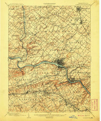
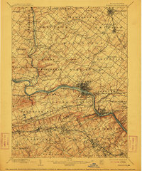
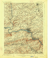
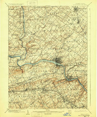
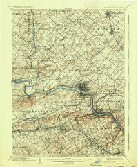
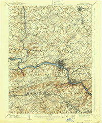
1895 Map of Norristown
USGS Topo · Published 1918About this map
The Schuylkill River and its major tributaries, including Perkiomen Creek and Skippack Creek, define the industrial and agricultural landscape of this southeastern Pennsylvania region. In the final years of the 19th century, a dense network of rail lines including the Philadelphia and Reading RR and Pennsylvania RR connects established boroughs like Lansdale and North Wales to the industrial hub at Norristown. The map records a transition from the mill-driven economy of places like W Spring Mill to the growing suburban and commuter rail pattern emerging in Lower Merion and Radnor. Rural life is still anchored by landmarks such as the Perkiomen Bridge and local gathering points like Bethel Ch and Providence Square. The presence of a Mine near Audubon and various mills along the watercourses illustrates the diverse extraction and processing industries that flourished before the widespread electrification of the 20th century.
Find a feature on this map
164 named features on this map. Tap any name to fly to it.
Don’t see what you’re looking for? This feature index may not catch every label — zoom into the map to look around manually.
Map Details
Editions of this 1895 Norristown Map
11 editions found

1898 edition
16.6 x 19.9 inches
1901 edition
16.5 x 20.4 inches
1906 edition
16.6 x 20.3 inches
1908 edition
16.6 x 19.9 inches
1912 edition
16.5 x 19.9 inches
1918 edition
16 x 19.7 inches
1926 edition
16.5 x 19.9 inches
1929 edition
16.6 x 19.9 inches
1936 edition
16.5 x 19.9 inches
1942 edition
16.5 x 19.9 inches
1950 edition
17 x 20.9 inches
Other maps of this area

1888 · Quakertown
USGS Topo · 1:62,500

1890 · Doylestown
USGS Topo · 1:62,500

1890 · Quakertown
USGS Topo · 1:62,500

1891 · Doylestown
USGS Topo · 1:62,500

1891 · Philadelphia
USGS Topo · 1:62,500

1893 · Germantown
USGS Topo · 1:62,500

1894 · Quakertown
USGS Topo · 1:62,500

1894 · Chester
USGS Topo · 1:62,500

1894 · Philadelphia
USGS Topo · 1:62,500

1894 · Norristown
USGS Topo · 1:62,500
Featured Places
- Philadelphia, PA
- Norristown, PA
- Radnor Township, PA
- King of Prussia, Upper Merion Township
- Whitemarsh Township, PA