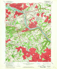
1966 Map of Norristown
USGS Topo · Published 1968About this map
The Schuylkill River carves a deep industrial and transportation corridor through this mid-1960s landscape, separating the urban density of Norristown and Bridgeport from the emerging suburban expanses of the Main Line. This period captures a significant transition as the massive infrastructure of the Schuylkill Expressway and Pennsylvania Turnpike cuts across older settlement patterns. Educational and religious institutions anchor the surrounding communities, notably Villanova University, Bryn Mawr College, and Haverford College. Extensive rail networks of the Penn Central and Reading lines parallel the river, serving industrial sites like Barbadoes Island and Swedeland. Large green spaces, including Riverside Cemetery and Calvary Cemetery, are interspersed with numerous golf clubs, reflecting the regional shift from heavy industry toward residential and institutional development during the post-war era.
Find a feature on this map
115 named features on this map. Tap any name to fly to it.
Don’t see what you’re looking for? This feature index may not catch every label — zoom into the map to look around manually.
Map Details
Editions of this 1966 Norristown Map
3 editions found
Other maps of this area

1891 · Philadelphia
USGS Topo · 1:62,500

1893 · Germantown
USGS Topo · 1:62,500

1894 · Chester
USGS Topo · 1:62,500

1894 · Philadelphia
USGS Topo · 1:62,500

1894 · Norristown
USGS Topo · 1:62,500

1894 · Germantown
USGS Topo · 1:62,500

1895 · Norristown
USGS Topo · 1:62,500

1896 · Germantown
USGS Topo · 1:62,500

1896 · Philadelphia
USGS Topo · 1:62,500

1896 · Norristown
USGS Topo · 1:62,500
Featured Places
- Philadelphia, PA
- Norristown, PA
- Radnor Township, PA
- King of Prussia, Upper Merion Township
- Whitemarsh Township, PA