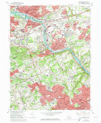
1966 Map of Norristown
USGS Topo · Published 1974About this map
The Schuylkill River carves a deep path through this mid-1960s landscape, serving as the industrial and transit spine for Norristown, Conshohocken, and West Conshohocken. The river's banks are dense with infrastructure, from the Filtration Plant and Sewage Disposal works to the massive Barbadoes Island. This era is defined by the heavy footprint of rail and road, with the Penn Central and Reading railroads paralleling the water, while the Pennsylvania Turnpike and Schuylkill Expressway facilitate rapid suburban expansion.
Find a feature on this map
148 named features on this map. Tap any name to fly to it.
Don’t see what you’re looking for? This feature index may not catch every label — zoom into the map to look around manually.
Map Details
Editions of this 1966 Norristown Map
3 editions found
Other maps of this area

1891 · Philadelphia
USGS Topo · 1:62,500

1893 · Germantown
USGS Topo · 1:62,500

1894 · Chester
USGS Topo · 1:62,500

1894 · Philadelphia
USGS Topo · 1:62,500

1894 · Norristown
USGS Topo · 1:62,500

1894 · Germantown
USGS Topo · 1:62,500

1895 · Norristown
USGS Topo · 1:62,500

1896 · Germantown
USGS Topo · 1:62,500

1896 · Philadelphia
USGS Topo · 1:62,500

1896 · Norristown
USGS Topo · 1:62,500
Featured Places
- Philadelphia, PA
- Norristown, PA
- Radnor Township, PA
- King of Prussia, Upper Merion Township
- Whitemarsh Township, PA