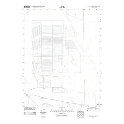
2010 Map of North Avondale
USGS Topo · Published 2010About this map
North Avondale and the town of Boone anchor this high-plains landscape just east of the Pueblo Ordnance Depot. The area is defined by a dense grid of irrigation and transport infrastructure, where the Arkansas River flows along the southern edge and the Colorado Canal cuts through the dry terrain. The map reveals the organized geometry of ranching and land management, with prominent drainage systems including Chico Creek, Haynes Creek, and Boone Creek feeding into the river valley.
Find a feature on this map
14 named features on this map. Tap any name to fly to it.
Don’t see what you’re looking for? This feature index may not catch every label — zoom into the map to look around manually.
Map Details
Editions of this 2010 North Avondale Map
This is the sole edition of this map. No revisions or reprints were ever made.
Other maps of this area

1891 · Nepesta
USGS Topo · 1:125,000

1893 · Nepesta
USGS Topo · 1:125,000

1904 · Nepesta
USGS Topo · 1:125,000

1954 · Pueblo
USGS Topo · 1:250,000

1957 · Pueblo
USGS Topo · 1:250,000

1958 · Pueblo
USGS Topo · 1:250,000

1959 · Highlands Church
USGS Topo · 1:24,000

1959 · North Avondale NE
USGS Topo · 1:24,000
1960 · Nepesta
USGS Topo · 1:24,000
1960 · Boone Hill
USGS Topo · 1:24,000