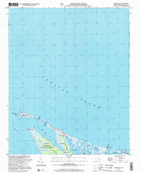
2002 Map of North Bay
USGS Topo · Published 2002About this map
Cedar Island dominates this coastal landscape where the waters of Pamlico Sound meet the marshy edges of West Bay and North Bay. Much of the territory is defined by the Cedar Island National Wildlife Refuge, preserving a complex network of wetlands and small islands. Notable landmarks include the Goodwin Hills and Head of Bay, while a small Cem near the southern boundary provides a point of interest for genealogists tracing local families in this maritime environment.
Find a feature on this map
28 named features on this map. Tap any name to fly to it.
Don’t see what you’re looking for? This feature index may not catch every label — zoom into the map to look around manually.
Map Details
Editions of this 2002 North Bay Map
This is the sole edition of this map. No revisions or reprints were ever made.
Other maps of this area

1948 · North Bay
USGS Topo · 1:24,000

1949 · Atlantic
USGS Topo · 1:24,000

1949 · Point Of Marsh
USGS Topo · 1:24,000

1949 · Long Bay
USGS Topo · 1:24,000

1950 · Long Bay
USGS Topo · 1:24,000

1950 · North Bay
USGS Topo · 1:24,000

1950 · Point Of Marsh
USGS Topo · 1:24,000
1951 · Atlantic
USGS Topo · 1:24,000

1951 · Brant Island
USGS Topo · 1:24,000

1953 · Rocky Mount
USGS Topo · 1:250,000