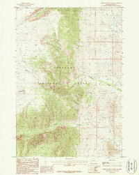
1987 Map of North Bennett Creek
USGS Topo · Published 1987About this map
Shoshone National Forest encompasses this dramatic terrain in Park County, where steep ridgelines give way to an intricate network of alpine drainages. The landscape is defined by the headwaters of North Bennett Creek, Bennett Creek, and Littlerock Creek, which carve deep paths through the high country. In the western portion of the sheet, the massive bulk of Tolman Mountain dominates the skyline, while the eastern slopes transition toward more accessible reaches marked by a lonely Grave and the historical Lake Creek Ditch. Movement through this wilderness is documented by a designated Pack Trail and various 4wd routes, reflecting the area's remote character in the late 1980s. A notable landmark, Hole in Wall Cave, is situated along the central ridge, providing a specific point of interest for those studying the geology or local history of this section of Wyoming.
Find a feature on this map
14 named features on this map. Tap any name to fly to it.
Don’t see what you’re looking for? This feature index may not catch every label — zoom into the map to look around manually.
Map Details
Editions of this 1987 North Bennett Creek Map
This is the sole edition of this map. No revisions or reprints were ever made.
Other maps of this area

1944 · Red Lodge
USGS Topo · 1:62,500

1950 · Clark
USGS Topo · 1:62,500

1950 · Deep Lake
USGS Topo · 1:62,500

1954 · Billings
USGS Topo · 1:250,000

1955 · Cody
USGS Topo · 1:250,000

1956 · Mount Maurice
USGS Topo · 1:62,500

1957 · Billings
USGS Topo · 1:250,000

1958 · Billings
USGS Topo · 1:250,000

1958 · Cody
USGS Topo · 1:250,000

1962 · Cody
USGS Topo · 1:250,000