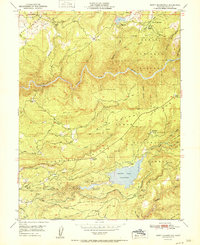
1951 Map of North Bloomfield
USGS Topo · Published 1951About this map
San Juan Ridge and its neighboring plateaus define this landscape, where the scars of hydraulic mining remain evident at sites like the Malakoff Diggings. The map captures the complex water management system of the mid-20th century, featuring the Scotts Flat Reservoir and an intricate network of infrastructure including the Blue Ditch, various canals, and flumes designed to move water across the ridgelines. These systems supported both remnant mining operations at the Hoge Mine and Murchie Mine as well as local ranching at Kirkham Ranch and Casci Ranch.
Find a feature on this map
61 named features on this map. Tap any name to fly to it.
Don’t see what you’re looking for? This feature index may not catch every label — zoom into the map to look around manually.
Map Details
Editions of this 1951 North Bloomfield Map
This is the sole edition of this map. No revisions or reprints were ever made.
Other maps of this area

1888 · Smartsville
USGS Topo · 1:125,000

1891 · Colfax
USGS Topo · 1:125,000

1891 · Smartsville
USGS Topo · 1:125,000

1892 · Smartsville
USGS Topo · 1:125,000

1892 · Colfax
USGS Topo · 1:125,000

1894 · Colfax
USGS Topo · 1:125,000

1894 · Smartsville
USGS Topo · 1:125,000

1895 · Smartsville
USGS Topo · 1:125,000

1898 · Colfax
USGS Topo · 1:125,000

1900 · Colfax
USGS Topo · 1:125,000