
1967 Map of North Brookfield
USGS Topo · Published 1978About this map
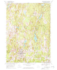
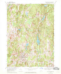
North Brookfield serves as the primary municipal hub in this late 1960s topographic survey of Worcester County, where the transition from industrial town centers to dense woodlands is clearly visible. The landscape is defined by its many glacial water bodies, including the centrally located Brooks Pond and Dean Pond, which sit adjacent to the sprawling Oakham State Forest. For genealogists and local historians, the map is remarkably detailed regarding burial grounds, marking sites like Walnut Grove Cem and the St Josephs Cem near the town center, as well as the secluded Southwest Cem. Religious and recreational landmarks are prominent, notably the St Josephs Abbey in Spencer and Camp Putnam in Oakham. Transportation is dominated by a network of historic routes like the Old Turnpike Road and the Penn Central rail line running through the northern reaches near the Ware River.
Find a feature on this map
59 named features on this map. Tap any name to fly to it.
Don’t see what you’re looking for? This feature index may not catch every label — zoom into the map to look around manually.
Map Details
Editions of this 1967 North Brookfield Map
3 editions found
Other maps of this area

1885 · Worcester
USGS Topo · 1:62,500

1886 · Worcester
USGS Topo · 1:62,500

1887 · Brookfield
USGS Topo · 1:62,500

1887 · Barre
USGS Topo · 1:62,500

1889 · Webster
USGS Topo · 1:62,500

1889 · Barre
USGS Topo · 1:62,500

1890 · Brookfield
USGS Topo · 1:62,500

1892 · Webster
USGS Topo · 1:62,500

1892 · Worcester
USGS Topo · 1:62,500

1893 · Brookfield
USGS Topo · 1:62,500