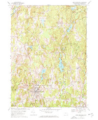
1967 Map of North Brookfield
USGS Topo · Published 1969About this map
North Brookfield serves as the primary hub of this Central Massachusetts landscape, where traditional village centers meet a network of family-named heights and water bodies. The terrain is defined by a series of prominent rises such as Tower Hill and Batcheller Hill, which separate the drainage basins of the Fivemile River and the Sevenmile River. The map captures a moment of transition for regional transportation, showing the Penn Central rail line cutting through the north, while the Old Turnpike Road reflects older colonial-era travel patterns. Notable religious and community institutions are well-represented, including the expansive grounds of St Josephs Abbey and numerous burial grounds like Green Hollow Cem and Pine Grove Cem, providing a detailed record of the area's social and genealogical fabric during the late 1960s.
Find a feature on this map
59 named features on this map. Tap any name to fly to it.
Don’t see what you’re looking for? This feature index may not catch every label — zoom into the map to look around manually.
Map Details
Editions of this 1967 North Brookfield Map
3 editions found

Other maps of this area

1885 · Worcester
USGS Topo · 1:62,500

1886 · Worcester
USGS Topo · 1:62,500

1887 · Brookfield
USGS Topo · 1:62,500

1887 · Barre
USGS Topo · 1:62,500

1889 · Webster
USGS Topo · 1:62,500

1889 · Barre
USGS Topo · 1:62,500

1890 · Brookfield
USGS Topo · 1:62,500

1892 · Webster
USGS Topo · 1:62,500

1892 · Worcester
USGS Topo · 1:62,500

1893 · Brookfield
USGS Topo · 1:62,500