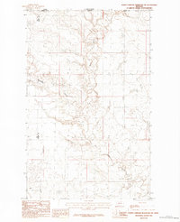
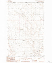
1984 Map of North Chinook Reservoir NW
USGS Topo · Published 1984About this map
Battle Creek meanders through this northern Montana landscape, defining the topography of a remote borderland where Blaine and Hill counties meet at the international boundary. This 1984 provisional study, based on 1970s aerial photography, documents a drainage system shaped by the deeply cut channels of Woodpile Coulee and Hay Coulee. The map provides an exact record of the Canada-United States border region, showing the surveyed line between Saskatchewan and Montana. While the area is largely devoid of named settlements, the intricate contour work captures the complex erosion patterns and watercourses that define this high-plains environment just north of the Chinook Reservoir region.
Find a feature on this map
7 named features on this map. Tap any name to fly to it.
Don’t see what you’re looking for? This feature index may not catch every label — zoom into the map to look around manually.
Map Details
Editions of this 1984 North Chinook Reservoir NW Map
This is the sole edition of this map. No revisions or reprints were ever made.
Other maps of this area

1912 · Zurich
USGS Topo · 1:125,000

1912 · Thibedeau Lake
USGS Topo · 1:125,000

1953 · Havre
USGS Topo · 1:250,000

1957 · Havre
USGS Topo · 1:250,000

1958 · Havre
USGS Topo · 1:250,000
1972 · Lake Thibadeau
USGS Topo · 1:24,000
1972 · Lake Thibadeau NE
USGS Topo · 1:24,000
1984 · Mc Laren Reservoir
USGS Topo · 1:24,000

1984 · Havre
USGS Topo · 1:100,000
1984 · North Chinook Reservoir NE
USGS Topo · 1:24,000