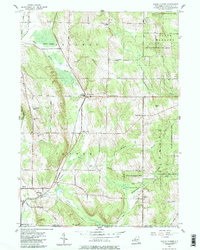
1954 Map of North Clymer
USGS Topo · Published 1985About this map
The Pennsylvania railroad line cuts a diagonal path through this corner of Chautauqua County, connecting the villages of Clymer and North Clymer during the mid-1950s. The landscape is defined by the headwaters of several drainages, including the Brokenstraw Creek and French Creek, which wind through lowlands like Perkins Swamp. This survey captures a rural network of named crossroads that serve as the local hubs for this farming and timber country, including Wait Corners, Wickwire Corners, and King Corners.
Find a feature on this map
42 named features on this map. Tap any name to fly to it.
Don’t see what you’re looking for? This feature index may not catch every label — zoom into the map to look around manually.
Map Details
Editions of this 1954 North Clymer Map
3 editions found
Other maps of this area

1904 · Chautaqua
USGS Topo · 1:62,500

1905 · Clymer
USGS Topo · 1:62,500

1926 · Youngsville
USGS Topo · 1:62,500

1929 · Corry
USGS Topo · 1:48,000

1929 · Youngsville
USGS Topo · 1:62,500

1932 · Corry
USGS Topo · 1:62,500

1939 · Clymer
USGS Topo · 1:62,500

1941 · Chautauqua
USGS Topo · 1:62,500

1941 · Clymer
USGS Topo · 1:62,500

1943 · Youngsville
USGS Topo · 1:62,500