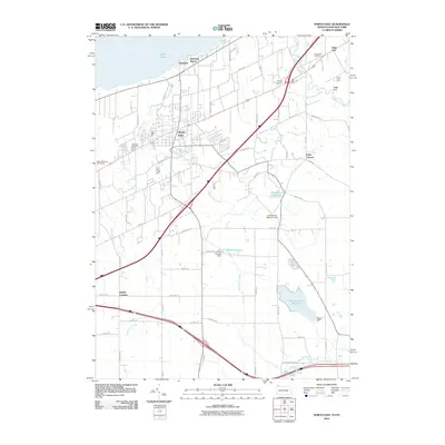
2010 Map of North East
USGS Topo · Published 2010About this map
Sixteenmile Creek and Twentymile Creek flow toward the shoreline of Lake Erie in this early 21st-century portrait of Erie County. The settlement of North East serves as the hub of a landscape defined by its agricultural heritage and water management, featuring notable sites like the Carris Fruit Farm and Gage Gulf. Reservoirs including Grahamville Reservoir, Smith Reservoir, and the Howard Eaton Reservoir illustrate the engineered infrastructure supporting the region. Local history is anchored by several burial grounds, such as Oak Hill Cemetery and Phillips Cemetery. Near the State Line, the map captures a transition between residential lakeside communities like Orchard Beach and the rural crossroads of Delhill Corners and Kerrs Corners.
Find a feature on this map
65 named features on this map. Tap any name to fly to it.
Don’t see what you’re looking for? This feature index may not catch every label — zoom into the map to look around manually.
Map Details
Editions of this 2010 North East Map
This is the sole edition of this map. No revisions or reprints were ever made.
Other maps of this area

1899 · Westfield
USGS Topo · 1:62,500

1905 · Clymer
USGS Topo · 1:62,500

1913 · North East
USGS Topo · 1:62,500

1915 · North East
USGS Topo · 1:62,500

1939 · Clymer
USGS Topo · 1:62,500

1941 · Clymer
USGS Topo · 1:62,500

1943 · North East
USGS Topo · 1:62,500

1954 · South Ripley
USGS Topo · 1:24,000

1954 · Ripley
USGS Topo · 1:24,000
1954 · Clymer
USGS Topo · 1:24,000