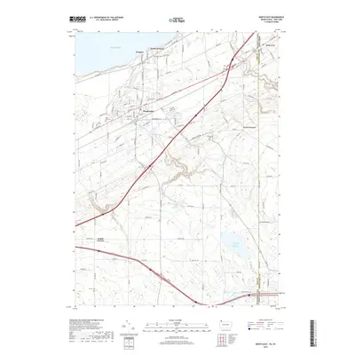
2019 Map of North East
USGS Topo · Published 2019About this map
The community of North East anchors this 2019 survey along the southern shore of Lake Erie, where the landscape transitions from lakeside orchards to the rising elevations of the Allegheny Plateau. This coastal region is defined by its drainage patterns, including Sixteenmile Cr and Twentymile Creek, which carve their way north toward the lake. Large-scale water management is evident in the Howard Eaton Reservoir and Grahamville Reservoir, providing critical infrastructure for the local area.
Find a feature on this map
110 named features on this map. Tap any name to fly to it.
Don’t see what you’re looking for? This feature index may not catch every label — zoom into the map to look around manually.
Map Details
Editions of this 2019 North East Map
This is the sole edition of this map. No revisions or reprints were ever made.
Other maps of this area

1899 · Westfield
USGS Topo · 1:62,500

1905 · Clymer
USGS Topo · 1:62,500

1913 · North East
USGS Topo · 1:62,500

1915 · North East
USGS Topo · 1:62,500

1939 · Clymer
USGS Topo · 1:62,500

1941 · Clymer
USGS Topo · 1:62,500

1943 · North East
USGS Topo · 1:62,500

1954 · South Ripley
USGS Topo · 1:24,000

1954 · Ripley
USGS Topo · 1:24,000
1954 · Clymer
USGS Topo · 1:24,000