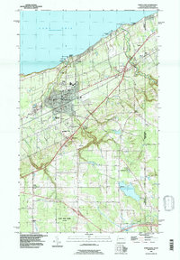
1996 Map of North East
USGS Topo · Published 1997About this map
The fruit-growing and lakeside landscape of North East is defined by its position along the Lake Erie shoreline and the state boundary of Pennsylvania and New York. This 1996 survey illustrates a well-developed network of infrastructure, where the New York State Thruway and Conrail rail lines cut through the terrain to support regional transport. Educational and religious institutions are concentrated in the borough, including Merryhurst College, St Peters Church, and Earl C Davis School.
Find a feature on this map
71 named features on this map. Tap any name to fly to it.
Don’t see what you’re looking for? This feature index may not catch every label — zoom into the map to look around manually.
Map Details
Editions of this 1996 North East Map
This is the sole edition of this map. No revisions or reprints were ever made.
Other maps of this area

1899 · Westfield
USGS Topo · 1:62,500

1905 · Clymer
USGS Topo · 1:62,500

1913 · North East
USGS Topo · 1:62,500

1915 · North East
USGS Topo · 1:62,500

1939 · Clymer
USGS Topo · 1:62,500

1941 · Clymer
USGS Topo · 1:62,500

1943 · North East
USGS Topo · 1:62,500

1954 · South Ripley
USGS Topo · 1:24,000

1954 · Ripley
USGS Topo · 1:24,000
1954 · Clymer
USGS Topo · 1:24,000