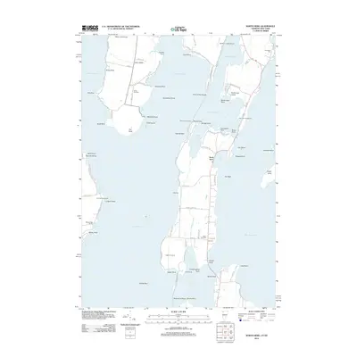
2012 Map of North Hero
USGS Topo · Published 2012About this map
North Hero Island and the eastern edge of Isle La Motte dominate this coastal survey of Lake Champlain. The map reveals a landscape defined by its relation to the water, where the village of North Hero sits along the narrow passage of The Gut. The region's history is preserved in several small burial grounds, including Hyde Cem and South End Cem, which serve as quiet markers of the generations who settled these shores. Along the interior roads like Old W Shore Rd and Maple Ridge Rd, the land remains largely defined by its rural character and proximity to seasonal recreational sites like Camp Abnaki and Ingalls 4-H Camp. Numerous points and bays, from Fisk Point to Savage Point, illustrate a jagged shoreline that has historically supported both agriculture and lake-based tourism.
Find a feature on this map
94 named features on this map. Tap any name to fly to it.
Don’t see what you’re looking for? This feature index may not catch every label — zoom into the map to look around manually.
Map Details
Editions of this 2012 North Hero Map
This is the sole edition of this map. No revisions or reprints were ever made.
Other maps of this area

1894 · Plattsburg
USGS Topo · 1:62,500

1895 · Rouse Point
USGS Topo · 1:62,500

1906 · Plattsburg
USGS Topo · 1:62,500

1907 · Rouse Point
USGS Topo · 1:62,500

1913 · Milton
USGS Topo · 1:48,000

1914 · St. Albans
USGS Topo · 1:48,000

1915 · Milton
USGS Topo · 1:62,500

1916 · St. Albans
USGS Topo · 1:62,500

1939 · Rouses Point
USGS Topo · 1:62,500

1939 · Plattsburg
USGS Topo · 1:62,500