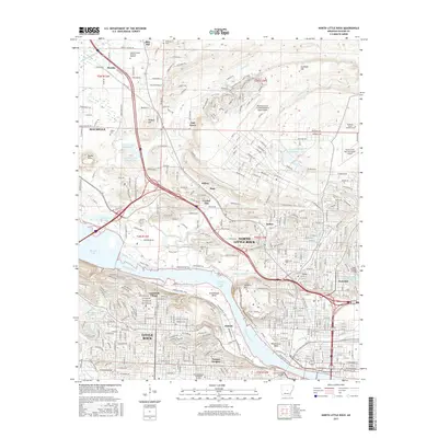
2017 Map of North Little Rock
USGS Topo · Published 2017About this map
North Little Rock and the surrounding suburban communities of Levy, Amboy, and Park Hill are shown in high detail as the metro area expanded in the late 2010s. The Arkansas River serves as the central geographic divide, with major infrastructure like the Lincoln Avenue Viaduct and the Union Pacific RR connecting the north and south banks. This survey illustrates the modern development of Cammack Village and Pulaski Heights against the river's significant bends, including Greathouse Bend and Waterworks Bend. To the north, the sprawling grounds of Camp Robinson and the Robinson Army Airfield/National Guard Airport dominate the landscape, bordered by several smaller communities like Marche and Oak Grove. Genealogists and historians will find the locations of numerous memorial sites well-documented, from the Arkansas State Veterans Cem to the older Palestine Cem and Corbin Cem.
Find a feature on this map
229 named features on this map. Tap any name to fly to it.
Don’t see what you’re looking for? This feature index may not catch every label — zoom into the map to look around manually.
Map Details
Editions of this 2017 North Little Rock Map
This is the sole edition of this map. No revisions or reprints were ever made.
Other maps of this area

1891 · Little Rock
USGS Topo · 1:125,000

1893 · Little Rock
USGS Topo · 1:125,000

1935 · Mc Almont
USGS Topo · 1:24,000

1935 · Little Rock
USGS Topo · 1:24,000

1935 · Sweet Home
USGS Topo · 1:24,000

1935 · North Little Rock
USGS Topo · 1:24,000

1935 · Alexander
USGS Topo · 1:48,000

1941 · Alexander
USGS Topo · 1:62,500

1941 · Olmstead
USGS Topo · 1:31,680

1943 · Pinnacle Mtn
USGS Topo · 1:31,680