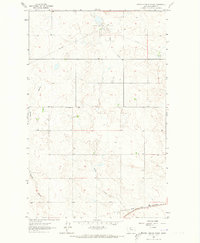
1962 Map of North Lothair School
USGS Topo · Published 1973About this map
Utopia Gas and Oil Field marks the northern reaches of this Montana landscape, where industrial extraction and rural education shared the high plains. The presence of the North Lothair Sch near the center of the survey area suggests a distributed ranching community reliant on localized centers. The southern boundary is defined by the logistics of the era, featuring the Great Northern rail line and an Old Railroad Grade that speaks to shifting transportation routes. Drainage for this semi-arid terrain is provided by Eagle Creek and the deep Galata Ravine, which carve distinct paths through the sections. Traces of modern infrastructure are evident in the diagonal Pipeline cutting across the northern townships, contrasting with the traditional ranching grid.
Find a feature on this map
10 named features on this map. Tap any name to fly to it.
Don’t see what you’re looking for? This feature index may not catch every label — zoom into the map to look around manually.
Map Details
Editions of this 1962 North Lothair School Map
2 editions found
Other maps of this area

1954 · Shelby
USGS Topo · 1:250,000

1958 · Shelby
USGS Topo · 1:250,000

1962 · Tiber
USGS Topo · 1:24,000

1962 · Lakey Ranch
USGS Topo · 1:24,000

1962 · North Lothair School
USGS Topo · 1:24,000

1962 · Berkholder Reservoir
USGS Topo · 1:24,000

1962 · Blair Ranch
USGS Topo · 1:24,000

1962 · Mc Carters Lake SE
USGS Topo · 1:24,000

1970 · Sagebrush Coulee
USGS Topo · 1:24,000

1970 · Galata
USGS Topo · 1:24,000