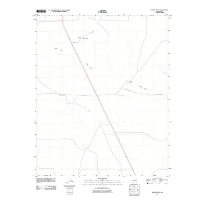
2010 Map of North Lucy
USGS Topo · Published 2010About this map
Red Hills Cemetery and the high point of Red Hill anchor this high plains landscape in Torrance County. The small settlement of North Lucy sits at the intersection of local routes, including County RD-C094, serving as a focal point for the surrounding ranching country. The map illustrates a sparse but deliberate network of county roads like County RD-C091 and County RD-C092 that connect isolated properties across the arid terrain. Pintada Draw provides the primary drainage through this region, its meandering course carving through the open spaces south of Bigbee Ranch. This 2010 survey reflects the enduring character of New Mexico's rangelands, where water features and family-named landmarks provide the essential framework for navigation and local history.
Find a feature on this map
9 named features on this map. Tap any name to fly to it.
Don’t see what you’re looking for? This feature index may not catch every label — zoom into the map to look around manually.
Map Details
Editions of this 2010 North Lucy Map
This is the sole edition of this map. No revisions or reprints were ever made.
Other maps of this area

1954 · Fort Sumner
USGS Topo · 1:250,000

1958 · Fort Sumner
USGS Topo · 1:250,000
1978 · Waller Ranch
USGS Topo · 1:24,000

1978 · Pedernal Mountain
USGS Topo · 1:24,000

1978 · Pedernal
USGS Topo · 1:24,000

1978 · North Lucy
USGS Topo · 1:24,000

1978 · Santo Nino Canyon
USGS Topo · 1:24,000
1978 · Rock Lake
USGS Topo · 1:24,000

1978 · Encino
USGS Topo · 1:24,000

1978 · Negra
USGS Topo · 1:24,000