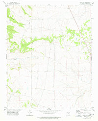
1978 Map of Rock Lake
USGS Topo · Published 1978About this map
Rock Lake and Texas Lake sit as isolated water bodies in this high-altitude landscape of Torrance County, captured during a 1970s Geological Survey. The terrain is defined by dramatic drainage patterns, including the winding Rattlesnake Draw in the northwest and Mc Gillivray Draw in the southwest. A prominent Red Canyon cuts through the central-western portion of the quadrangle, illustrating the complex erosional history of this region. Human activity in the area is marked by a long industrial pipeline that traverses the northern sections, alongside several gravel pits that suggest local resource extraction. The map serves as a record of the rural land divisions at the intersection of Range 11 East and Range 12 East, where the transition between Township 9 North and Township 8 North occurs amidst a network of unimproved roads and survey sections.
Find a feature on this map
9 named features on this map. Tap any name to fly to it.
Don’t see what you’re looking for? This feature index may not catch every label — zoom into the map to look around manually.
Map Details
Editions of this 1978 Rock Lake Map
This is the sole edition of this map. No revisions or reprints were ever made.
Other maps of this area

1894 · Lamy
USGS Topo · 1:125,000

1954 · Santa Fe
USGS Topo · 1:250,000

1954 · Fort Sumner
USGS Topo · 1:250,000

1958 · Fort Sumner
USGS Topo · 1:250,000

1958 · Santa Fe
USGS Topo · 1:250,000

1960 · Lobo Hill
USGS Topo · 1:62,500

1960 · Stanley
USGS Topo · 1:62,500
1966 · El Cabo
USGS Topo · 1:24,000
1966 · Clines Corners
USGS Topo · 1:24,000
1978 · Waller Ranch
USGS Topo · 1:24,000