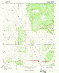
1966 Map of Clines Corners
USGS Topo · Published 1970About this map
Clines Corners serves as the focal point for this mid-1960s survey, marking a significant crossroads where the high plains terrain meets the infrastructure of the interstate era. This landscape, where Santa Fe, San Miguel, and Torrance counties converge, is defined by its ranching heritage and water management. Numerous family-named landmarks such as Tapia Ranch and the Tapia Cem reflect the local lineage, while the presence of the San Antonio Ch suggests a centered community life amidst the arid draws. The map illustrates a reliance on artificial water sources, documented through a dense network of catchments like Frank Tapia Tank, Ricardo Tank, and Fence Tank. Beyond the ranches, the terrain rises toward Mesa Las Tapia and the Rincon Agua Verde, while a Landing Strip near the highway junction points to the area's role as a transit waypoint in central New Mexico.
Find a feature on this map
40 named features on this map. Tap any name to fly to it.
Don’t see what you’re looking for? This feature index may not catch every label — zoom into the map to look around manually.
Map Details
Editions of this 1966 Clines Corners Map
This is the sole edition of this map. No revisions or reprints were ever made.
Other maps of this area

1894 · Lamy
USGS Topo · 1:125,000

1954 · Santa Fe
USGS Topo · 1:250,000

1954 · Fort Sumner
USGS Topo · 1:250,000

1958 · Fort Sumner
USGS Topo · 1:250,000

1958 · Santa Fe
USGS Topo · 1:250,000

1960 · Lobo Hill
USGS Topo · 1:62,500

1960 · Stanley
USGS Topo · 1:62,500
1966 · El Cabo
USGS Topo · 1:24,000
1966 · Mesa El Toro
USGS Topo · 1:24,000
1966 · Leyba
USGS Topo · 1:24,000