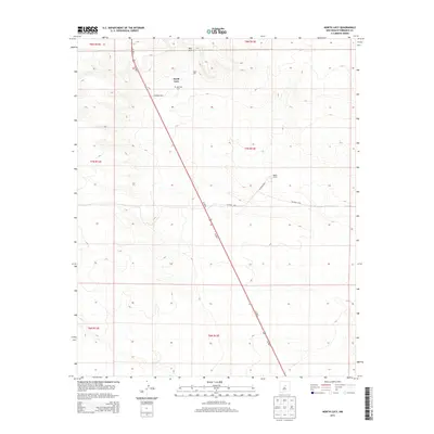
2013 Map of North Lucy
USGS Topo · Published 2013About this map
North Lucy and the surrounding high plains of Torrance County are defined by a sparse settlement pattern and a transition into elevated terrain. The most prominent natural landmark is Red Hill, which overlooks the small community and the nearby Red Hills Cem. This landscape represents a quiet agricultural and ranching corridor in central New Mexico, where large holdings like the Bigbee Ranch are connected by a network of county roads including CO Road C094 and CO Road C096. The primary artery of travel through this region is the divided highway of Us-285 N and Us-285 S, which cuts a straight path through the township and range grids. The map provides a clear look at the intersection of local ranch roads with this major thoroughfare, reflecting the persistent rural character of the area in the early twenty-first century.
Find a feature on this map
15 named features on this map. Tap any name to fly to it.
Don’t see what you’re looking for? This feature index may not catch every label — zoom into the map to look around manually.
Map Details
Editions of this 2013 North Lucy Map
This is the sole edition of this map. No revisions or reprints were ever made.
Other maps of this area

1954 · Fort Sumner
USGS Topo · 1:250,000

1958 · Fort Sumner
USGS Topo · 1:250,000
1978 · Waller Ranch
USGS Topo · 1:24,000

1978 · Pedernal Mountain
USGS Topo · 1:24,000

1978 · Pedernal
USGS Topo · 1:24,000

1978 · North Lucy
USGS Topo · 1:24,000

1978 · Santo Nino Canyon
USGS Topo · 1:24,000
1978 · Rock Lake
USGS Topo · 1:24,000

1978 · Encino
USGS Topo · 1:24,000

1978 · Negra
USGS Topo · 1:24,000