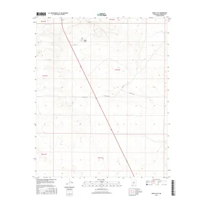
2017 Map of North Lucy
USGS Topo · Published 2017About this map
North Lucy and the surrounding high desert of Torrance County are defined by a sparse network of ranching roads and isolated landmarks in this 2017 survey. The landscape is punctuated by Red Hill in the northern reaches, a prominent elevation change near the Red Hills Cem. This small burial ground serves as a primary genealogical marker for the area, anchoring the history of local families to the land near the head of the valley. US Highway 285 bisects the quadrangle diagonally, providing the main artery through a region otherwise served by private and county routes like Harral Ranch Rd and Big's Bee Ranch Rd. The survey reveals a settlement pattern dictated by ranch boundaries and topographically sheltered pockets, characteristic of modern rural New Mexico where land use remains tied to large-scale cattle operations.
Find a feature on this map
14 named features on this map. Tap any name to fly to it.
Don’t see what you’re looking for? This feature index may not catch every label — zoom into the map to look around manually.
Map Details
Editions of this 2017 North Lucy Map
This is the sole edition of this map. No revisions or reprints were ever made.
Other maps of this area

1954 · Fort Sumner
USGS Topo · 1:250,000

1958 · Fort Sumner
USGS Topo · 1:250,000
1978 · Waller Ranch
USGS Topo · 1:24,000

1978 · Pedernal Mountain
USGS Topo · 1:24,000

1978 · Pedernal
USGS Topo · 1:24,000

1978 · North Lucy
USGS Topo · 1:24,000

1978 · Santo Nino Canyon
USGS Topo · 1:24,000
1978 · Rock Lake
USGS Topo · 1:24,000

1978 · Encino
USGS Topo · 1:24,000

1978 · Negra
USGS Topo · 1:24,000