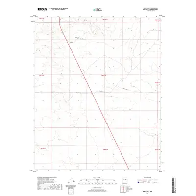
2020 Map of North Lucy
USGS Topo · Published 2020About this map
North Lucy and the surrounding high plains of Torrance County are depicted during a period of modern ranching and rural connectivity. The landscape is defined by the topographic rise of Red Hill to the north, which overlooks the isolated Red Hills Cem. This cemetery serves as a vital marker for genealogists and local historians, anchoring the family histories of this arid region. The map illustrates a sparse but essential network of ranch roads, such as Haral Ranch Rd and Big's Bee Ranch Rd, which facilitate movement across the large parcels of land characteristic of central New Mexico. These transit routes, including Co Rd C094, reflect the enduring importance of road-linked ranching economies in a terrain where natural water features are noticeably absent.
Find a feature on this map
16 named features on this map. Tap any name to fly to it.
Don’t see what you’re looking for? This feature index may not catch every label — zoom into the map to look around manually.
Map Details
Editions of this 2020 North Lucy Map
This is the sole edition of this map. No revisions or reprints were ever made.
Other maps of this area

1954 · Fort Sumner
USGS Topo · 1:250,000

1958 · Fort Sumner
USGS Topo · 1:250,000
1978 · Waller Ranch
USGS Topo · 1:24,000

1978 · Pedernal Mountain
USGS Topo · 1:24,000

1978 · Pedernal
USGS Topo · 1:24,000

1978 · North Lucy
USGS Topo · 1:24,000

1978 · Santo Nino Canyon
USGS Topo · 1:24,000
1978 · Rock Lake
USGS Topo · 1:24,000

1978 · Encino
USGS Topo · 1:24,000

1978 · Negra
USGS Topo · 1:24,000