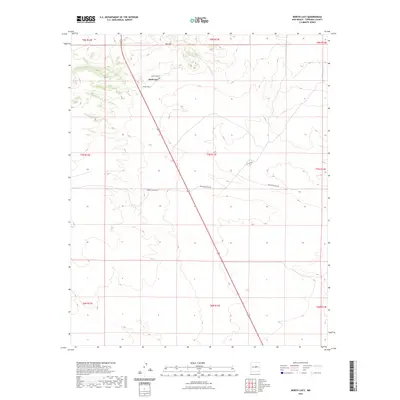
2023 Map of North Lucy
USGS Topo · Published 2023About this map
North Lucy sits within a landscape defined by the prominent elevation of Red Hill and the presence of the Red Hills Cem, serving as a quiet focal point for this section of Torrance County. The terrain is crisscrossed by a sparse network of rural roads that hint at the ranching heritage of the region, including Harral Ranch Rd and Big's Bee Ranch Rd. These routes connect isolated homesteads and grazing lands, illustrating the expansive, low-density settlement pattern characteristic of this part of New Mexico. The map provides a clear look at the intersection of local infrastructure and the natural topography, where county roads like Co RD c094 and Co RD c095 navigate around the contours of the high desert environment.
Find a feature on this map
16 named features on this map. Tap any name to fly to it.
Don’t see what you’re looking for? This feature index may not catch every label — zoom into the map to look around manually.
Map Details
Editions of this 2023 North Lucy Map
This is the sole edition of this map. No revisions or reprints were ever made.
Other maps of this area

1954 · Fort Sumner
USGS Topo · 1:250,000

1958 · Fort Sumner
USGS Topo · 1:250,000
1978 · Waller Ranch
USGS Topo · 1:24,000

1978 · Pedernal Mountain
USGS Topo · 1:24,000

1978 · Pedernal
USGS Topo · 1:24,000

1978 · North Lucy
USGS Topo · 1:24,000

1978 · Santo Nino Canyon
USGS Topo · 1:24,000
1978 · Rock Lake
USGS Topo · 1:24,000

1978 · Encino
USGS Topo · 1:24,000

1978 · Negra
USGS Topo · 1:24,000