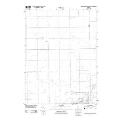
2010 Map of North Manchester North
USGS Topo · Published 2010About this map
The Eel River and its numerous tributaries, including Swank Creek, Plunge Creek, and Clear Creek, define the agricultural landscape north of North Manchester. This 2010 survey illustrates the town's northern expansion, centered around the Peabody Memorial Home and the grid surrounding W 9th St. The surrounding countryside is marked by a legacy of rural interment, with several family and community burial grounds documented across the terrain, such as Clemmers-Fishers Cemetery in the northeast and Gospel Hill Cemetery near Beigh Lake.
Find a feature on this map
45 named features on this map. Tap any name to fly to it.
Don’t see what you’re looking for? This feature index may not catch every label — zoom into the map to look around manually.
Map Details
Editions of this 2010 North Manchester North Map
This is the sole edition of this map. No revisions or reprints were ever made.
Other maps of this area

1950 · Pierceton
USGS Topo · 1:24,000

1953 · Fort Wayne
USGS Topo · 1:250,000

1953 · Muncie
USGS Topo · 1:250,000

1956 · Muncie
USGS Topo · 1:250,000

1956 · Fort Wayne
USGS Topo · 1:250,000

1957 · Warsaw
USGS Topo · 1:24,000

1961 · Silver Lake
USGS Topo · 1:24,000

1961 · Roann
USGS Topo · 1:24,000
1961 · Servia
USGS Topo · 1:24,000
1961 · North Manchester South
USGS Topo · 1:24,000