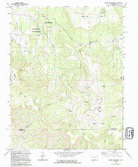
1994 Map of North Mountain
USGS Topo · Published 1994About this map
North Mountain dominates the landscape of this high-plateau region on the border of San Miguel and Dolores counties. The topography is defined by massive landforms like Hamilton Mesa and Island Mesa, carved by a network of seasonal watercourses such as Dry Creek and Nelson Creek. This 1994 edition, based on earlier surveys, reveals a landscape utilized for ranching and resource management, evidenced by Jensens Cow Camp and several corrals scattered throughout the basins. Local transit is primarily facilitated by primitive paths like the Butterfly Trail and the Old Salt Grade Road. The map also details the extensive Dry Creek Basin State Wildlife Area, while human activity is further indicated by radio towers and facilities near the mountain peaks. Small bodies of water including Spencer Lake and Galloway Lake provide critical points of interest in this arid terrain.
Find a feature on this map
40 named features on this map. Tap any name to fly to it.
Don’t see what you’re looking for? This feature index may not catch every label — zoom into the map to look around manually.
Map Details
Editions of this 1994 North Mountain Map
This is the sole edition of this map. No revisions or reprints were ever made.
Other maps of this area

1916 · Paradox Valley
USGS Topo · 1:125,000

1922 · Paradox Valley
USGS Topo · 1:125,000

1956 · Cortez
USGS Topo · 1:250,000

1956 · Moab
USGS Topo · 1:250,000

1958 · Cortez
USGS Topo · 1:250,000

1959 · Cortez
USGS Topo · 1:250,000

1959 · Moab
USGS Topo · 1:250,000

1960 · Moab
USGS Topo · 1:250,000

1962 · Moab
USGS Topo · 1:250,000

1962 · Cortez
USGS Topo · 1:250,000