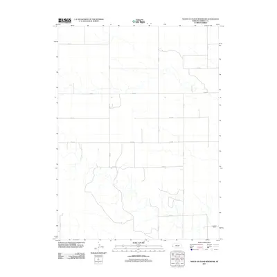
2011 Map of North of Oliver Reservoir
USGS Topo · Published 2011About this map
The High Plains of Kimball County are defined here by a systematic grid of section-line roads and the intermittent drainage patterns typical of Nebraska's western reaches. The most prominent structural landmark is the Lukassen Dam in the southeast, situated near a complex of dry creek beds and agricultural pathways. The landscape is primarily organized by a series of named county roads, including Co Rd-23 and Co Rd-27 running north-south, intersected by latitudinal routes such as Road 48 and Co Rd-44. This network reflects the region's enduring reliance on large-scale ranching and farming, where the placement of dams and local transport routes are vital to the management of this arid environment. The map captures the quiet, expansive character of the rural Nebraska panhandle in the early twenty-first century.
Find a feature on this map
15 named features on this map. Tap any name to fly to it.
Don’t see what you’re looking for? This feature index may not catch every label — zoom into the map to look around manually.
Map Details
Editions of this 2011 North of Oliver Reservoir Map
This is the sole edition of this map. No revisions or reprints were ever made.
Other maps of this area

1954 · Scottsbluff
USGS Topo · 1:250,000

1958 · Scottsbluff
USGS Topo · 1:250,000

1972 · Bushnell
USGS Topo · 1:24,000

1972 · Kimball
USGS Topo · 1:24,000

1972 · Oliver Reservoir
USGS Topo · 1:24,000

1973 · Kimball 2 NE
USGS Topo · 1:24,000

1973 · Kimball 2 SE
USGS Topo · 1:24,000
1973 · Kimball 2 SW
USGS Topo · 1:24,000
1973 · Kimball 2 NW
USGS Topo · 1:24,000

1973 · Kimball 1 NW
USGS Topo · 1:24,000