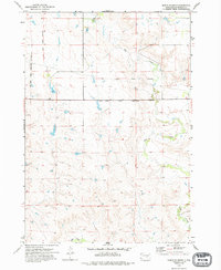
1973 Map of North Of Shelby
USGS Topo · Published 1994About this map
The Crow Creek Indian Reservation Boundary defines the northern and western margins of this landscape, reflecting historical land divisions in Buffalo County. Surveyed in the early 1970s, the terrain is shaped by the winding course of Elm Creek and the meandering Crow Creek, which flow through a region marked by extensive field lines and rural fencelines. A notable administrative feature is the Old Indian Reservation Boundary, which cuts across the central and northern sections of the map, providing a record of changing territorial limits. The map captures a largely open, hydrological landscape where seasonal drainages and small water bodies congregate near the creek basins, illustrating the agricultural and reservation layout of central South Dakota during this era.
Find a feature on this map
4 named features on this map. Tap any name to fly to it.
Don’t see what you’re looking for? This feature index may not catch every label — zoom into the map to look around manually.
Map Details
Editions of this 1973 North Of Shelby Map
2 editions found
Other maps of this area

1935 · Chamberlain
USGS Topo · 1:62,500

1939 · Chamberlain
USGS Topo · 1:62,500

1941 · Pukwana
USGS Topo · 1:62,500

1951 · Pukwana
USGS Topo · 1:62,500

1953 · Huron
USGS Topo · 1:250,000

1954 · Huron
USGS Topo · 1:250,000

1955 · Mitchell
USGS Topo · 1:250,000

1959 · Mitchell
USGS Topo · 1:250,000

1966 · Big Bend Dam NE
USGS Topo · 1:24,000

1966 · Big Bend Dam SE
USGS Topo · 1:24,000
Featured Places
- Fort Thompson District, SD
- Pershing Township, SD
- Crow Creek District, SD
- Wilson Township, Crow Creek District
- Dewey Township, Crow Creek District